


LUNAR SATELLITE IMAGES


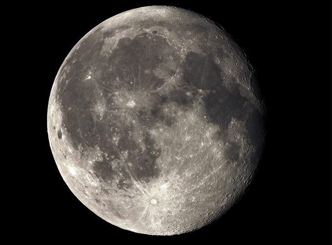
Jilin 1satellites can not only capture the images of the earth, but they can also turn the cameras to photograph space objects, such as the space station, the moon and other objects near the earth.
FeaturesofLunar Satellite Images
LUNAR SATELLITE IMAGES PARAMETERS
|
Indicators |
Parameter |
|
Angular resolution |
|
|
Standard duration |
10s; 30s; 60s |
|
Maximum duration |
120s |
|
Frame rate |
SP03-08:1/2/5/10 frame /s GF03C:1/2/5 frame /s (minimum 0.1, freely set) |
|
Standard field of view size |
SP03-08:1.1×0.5° for Single camera (SP04~08 is spliced by double cameras, and it is about 2.1×0.5°) GF03C series:1.5×0.6° |
|
Video image stabilization accuracy |
≤0.5 pixel |
|
Maximum angular velocity of maneuvering imaging |
≥ 1°/s |
|
Highest recognized magnitude |
SP03-08:12 magnitude GF03C series:10 magnitude |
|
Shooting satellite |
SP03-08; GF03C series |
If you want to know more types of commercial satellite, please contact us.
Send product request
Other supplier products
 |
INSURANCE SATELLITE REMOTE SENSING | Combining satellite and remote sensingtechnologies with rights confirmation data and land parcel segmentation technology can vectorize and spatiali... |
 |
SATELLITE CAMERAS | Satellite Cameras Specialized devices that take high-quality images from space. 5m-resolution Multispectral Camera 2m-resolution Micro-nano Ca... |
 |
LUNAR SATELLITE IMAGES | Jilin 1satellites can not only capture the images of the earth, but they can also turn the cameras to photograph space objects, such as the space s... |
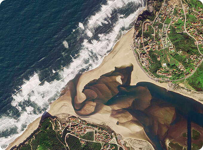 |
PUSH BROOM SCANNING SERVICE | The massive imagery archieved data and task programming data that cover all over the world captured by JL1constellation. Great view and great detai... |
 |
JL1 Satellite Manufacturing Product | Based on "the integration of satellite-borne" and other core technologies, CGSTL has set up the commercial business dealing with the development an... |
Same products
 |
PHOTOGRAMMETRY REMOTE SENSING | Seller: Chang Guang Satellite Technology Co., Ltd. | Photogrammetry remote sensingis to obtain reliable information about the earth, its environment a... |
 |
MARINE REMOTE SENSING | Seller: Chang Guang Satellite Technology Co., Ltd. | MARINE REMOTE SENSING Ocean colour remote sensingrefers to remote sensing that takes the ocean a... |
 |
NIGHT SATELLITE IMAGE | Seller: Chang Guang Satellite Technology Co., Ltd. | The SP and GF03C satellites of JL1 constellection can conduct fast shooting with high-resolutions... |
 |
MULTISPECTRAL IMAGES IN REMOTE SENSING | Seller: Chang Guang Satellite Technology Co., Ltd. | Multispectral remote sensing refers to the multispectral data remote sensingtechnology that divid... |
 |
MULTI SPECTRAL IMAGERY | Seller: Chang Guang Satellite Technology Co., Ltd. | The GP satellites of JL1 constellection have 26 spectral channels, covering optical remote sensin... |


