


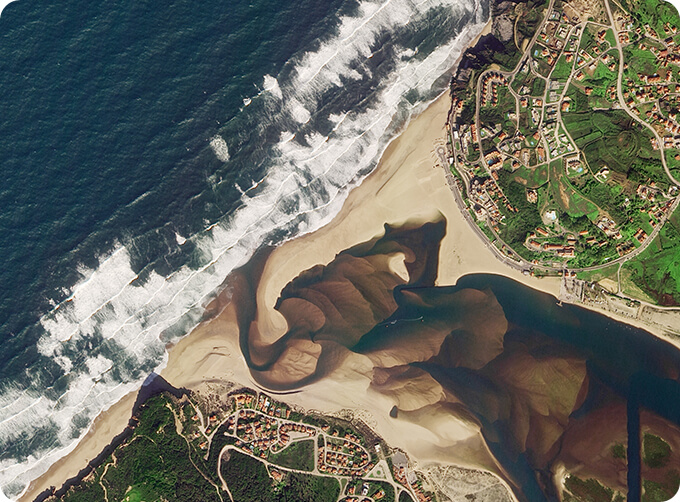
SATELLITE IMAGE MONITORING

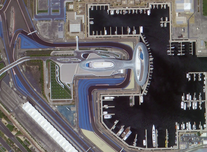
Change remote sensing monitoringuses multi-temporal remote sensing data, a variety of image processing and pattern recognition methods to extract change information, quantitatively analyze and determine the characteristics and processes of surface changes.
CONTENT OF HIGH-RESOLUTION REMOTE SENSING CHANGE MONITORING SERVICE PRODUCT OF CGSTL
|
Product name |
Service content |
Service frequency |
|
|
1 |
Remote sensing monitoring and supervision of "two violations" rectification |
The whole process management of illegal construction as well as illegal map, including upload, verification, classified disposal, distribution and rectification. |
Once a month |
|
(or customized in key areas) |
|||
|
2 |
Remote sensing monitoring of urban land use change |
Quick identification of the location and area information of urban land use change map based on intelligent change detection algorithm. |
Once a month |
|
3 |
Remote sensing monitoring of "four chaos" in rivers and lakes |
Remote sensing monitoring is carried out for the "four chaos" behaviors such as random construction, occupation, stacking and mining in the River and Lake Reserve, so as to achieve the effective tracking of the "four chaos" behaviors. |
Once a month |
|
4 |
Remote sensing monitoring in building stage of construction project |
Monitoring the building stage of construction projects objectively to provide decision-making and management basis for statistical investigation departments. |
Once a month |
|
(or customized in key areas) |
If you want to know more details of monitoring satelliteand satellite ozone monitoring, please visit our website.
ChangguangSatellite Technology Co., Ltd. ( CGSTL), founded on December 1st, 2014, it's a unique commercial aerospace enterprise with the development and operation of satellitechinaresearch, management as well as remote sensing information processing all in one. With a total registered capital of 1.97 billion RMB, the company comprises Jilin Provincial Government, Changchun Institute of Optics, Fine Mechanics and Physics (CIOMP), social capital, and technical backbone.
Send product request
Other supplier products
 |
PUSH BROOM SCANNING SERVICE | The massive imagery archieved data and task programming data that cover all over the world captured by JL1constellation. Great view and great detai... |
 |
PUSH BROOM SCANNING SERVICE | The massive imagery archieved data and task programming data that cover all over the world captured by Jilin 1constellation. Great view and great d... |
 |
SATELLITE MISSION PLANNING | CONSTELLATION MISSION PLANNING SYSTEM SATELLITE MISSION PLANNING SOFTWARE FEATURES 1 The constellation mission planning system can accept the sh... |
 |
PHOTOGRAMMETRY REMOTE SENSING | Photogrammetry remote sensingis to obtain reliable information about the earth, its environment and other natural objects and processes by using sa... |
 |
SATELLITE CAMERAS | Satellite Spy Camera Specialized devices that take high-quality images from space. 5m-resolution Multispectral Camera 2m-resolution Micro... |
Same products
 |
PHOTOGRAMMETRY REMOTE SENSING | Seller: Chang Guang Satellite Technology Co., Ltd. | Photogrammetry remote sensingis to obtain reliable information about the earth, its environment a... |
 |
MARINE REMOTE SENSING | Seller: Chang Guang Satellite Technology Co., Ltd. | MARINE REMOTE SENSING Ocean colour remote sensingrefers to remote sensing that takes the ocean a... |
 |
NIGHT SATELLITE IMAGE | Seller: Chang Guang Satellite Technology Co., Ltd. | The SP and GF03C satellites of JL1 constellection can conduct fast shooting with high-resolutions... |
 |
MULTISPECTRAL IMAGES IN REMOTE SENSING | Seller: Chang Guang Satellite Technology Co., Ltd. | Multispectral remote sensing refers to the multispectral data remote sensingtechnology that divid... |
 |
MULTI SPECTRAL IMAGERY | Seller: Chang Guang Satellite Technology Co., Ltd. | The GP satellites of JL1 constellection have 26 spectral channels, covering optical remote sensin... |


