PUSH BROOM SCANNING SERVICE


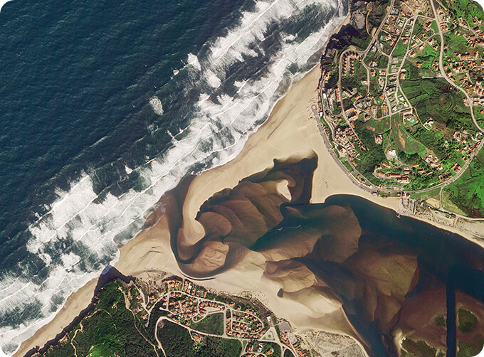
The massive imagery archieved data and task programming data that cover all over the world captured by JL1constellation. Great view and great details can be dicovered in our push broom scanningproduct.
The Resolution Is Better Than 0.5m Push Broom Scanning
The Resolution Is Better Than 0.75m Push Broom Scanning
The Resolution Is Better Than 1m Push Broom Scanning
FEATURES OF PUSH BROOM SCANNING SERVICE
1
Submeter high resolution (better than 0.5m)
2
High frequency revisit of point target
3
Fast coverage of large areas
4
Large shooting width (more than 150km)
OTHER JL1 SATELLITES DATA
Night Time Data
Satellite Image Video
LATEST NEWS ABOUT JL1
Satellite Remote SensingMonitoring for Refined Agricultural Production
If you want to know more kinds of along track scanner, please visit our website.
在线联系供应商
Other supplier products
 |
MULTI SPECTRAL IMAGERY | The GP satellites of JL1 constellection have 26 spectral channels, covering optical remote sensing data from visible light to long wave infrared. ... |
 |
SATELLITE IMAGE MONITORING | Change remote sensing monitoringuses multi-temporal remote sensing data, a variety of image processing and pattern recognition methods to extract c... |
 |
SATELLITE CAMERAS | Satellite Cameras Specialized devices that take high-quality images from space. 5m-resolution Multispectral Camera 2m-resolution Micro-nano Ca... |
 |
Satellite Remote Sensing | Remote sensing is a non-contact, long-distance detection technology. Relying on the unique global data set of JL1, using our big data intelligence ... |
 |
CUSTOMIZED SATELLITE TESTING SERVICE | Custom Satellite Solutions Jilin satellitecan provide customized remote-sensing information services to meet your specific needs. FEATURES OF C... |
Same products
 |
PHOTOGRAMMETRY REMOTE SENSING | 卖方: Chang Guang Satellite Technology Co., Ltd. | Photogrammetry remote sensingis to obtain reliable information about the earth, its environment a... |
 |
MARINE REMOTE SENSING | 卖方: Chang Guang Satellite Technology Co., Ltd. | MARINE REMOTE SENSING Ocean colour remote sensingrefers to remote sensing that takes the ocean a... |
 |
NIGHT SATELLITE IMAGE | 卖方: Chang Guang Satellite Technology Co., Ltd. | The SP and GF03C satellites of JL1 constellection can conduct fast shooting with high-resolutions... |
 |
MULTISPECTRAL IMAGES IN REMOTE SENSING | 卖方: Chang Guang Satellite Technology Co., Ltd. | Multispectral remote sensing refers to the multispectral data remote sensingtechnology that divid... |
|
|
MULTI SPECTRAL IMAGERY | 卖方: Chang Guang Satellite Technology Co., Ltd. | The GP satellites of JL1 constellection have 26 spectral channels, covering optical remote sensin... |