SATELLITE IMAGE MONITORING


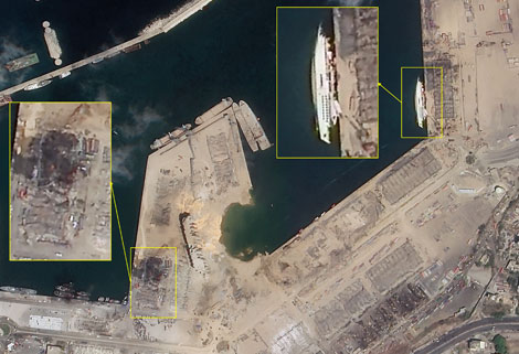
Change remote sensing monitoringuses multi-temporal remote sensing data, a variety of image processing and pattern recognition methods to extract change information, quantitatively analyze and determine the characteristics and processes of surface changes.
CONTENT OF HIGH-RESOLUTION REMOTE SENSING CHANGE MONITORING SERVICE PRODUCT OF CGSTL
|
Product name |
Service content |
Service frequency |
|
|
1 |
Remote sensing monitoring and supervision of "two violations" rectification |
The whole process management of illegal construction as well as illegal map, including upload, verification, classified disposal, distribution and rectification. |
Once a month (or customized in key areas) |
|
2 |
Remote sensing monitoring of urban land use change |
Quick identification of the location and area information of urban land use change map based on intelligent change detection algorithm. |
Once a month |
|
3 |
Remote sensing monitoring of "four chaos" in rivers and lakes |
Remote sensing monitoring is carried out for the "four chaos" behaviors such as random construction, occupation, stacking and mining in the River and Lake Reserve, so as to achieve the effective tracking of the "four chaos" behaviors. |
Once a month |
|
4 |
Remote sensing monitoring in building stage of construction project |
Monitoring the building stage of construction projects objectively to provide decision-making and management basis for statistical investigation departments. |
Once a month (or customized in key areas) |
Chang GuangSatellite Technology Co., Ltd. is a satellite factory, we provide earth monitoring satellites, satellite image monitoring, monitoring satellite, satellite ozone monitoring, volcano satellite monitoring, remote sensing satelliteetc. For more information, please feel free to contact us!
在线联系供应商
Other supplier products
 |
JL1 Satellite Services | The technical index and function mode in terms of satellites research are taking the leading position in the world. Various satellite services such... |
 |
MULTI SPECTRAL IMAGERY | The GP satellites of JL1 constellection have 26 spectral channels, covering optical remote sensing data from visible light to long wave infrared. ... |
 |
SATELLITE CAMERAS | Satellite Cameras Specialized devices that take high-quality images from space. 5m-resolution Multispectral Camera 2m-resolution Micro-nano Came... |
 |
Services | Bioanalytical Service Bioanalytical Service for Small Molecule Drugs and Metabolites, Large Molecules – Peptides and Proteins, etc. LCMSMS Q... |
 |
Satellite Remote Sensing | Satellite Remote Sensing Remote sensing is a non-contact, long-distance detection technology. Relying on the unique global data set of JL1, using ... |
Same products
 |
PHOTOGRAMMETRY REMOTE SENSING | 卖方: Chang Guang Satellite Technology Co., Ltd. | Photogrammetry remote sensingis to obtain reliable information about the earth, its environment a... |
 |
MARINE REMOTE SENSING | 卖方: Chang Guang Satellite Technology Co., Ltd. | MARINE REMOTE SENSING Ocean colour remote sensingrefers to remote sensing that takes the ocean a... |
 |
NIGHT SATELLITE IMAGE | 卖方: Chang Guang Satellite Technology Co., Ltd. | The SP and GF03C satellites of JL1 constellection can conduct fast shooting with high-resolutions... |
 |
MULTISPECTRAL IMAGES IN REMOTE SENSING | 卖方: Chang Guang Satellite Technology Co., Ltd. | Multispectral remote sensing refers to the multispectral data remote sensingtechnology that divid... |
|
|
MULTI SPECTRAL IMAGERY | 卖方: Chang Guang Satellite Technology Co., Ltd. | The GP satellites of JL1 constellection have 26 spectral channels, covering optical remote sensin... |