


SATELLITE DATA MANAGEMENT


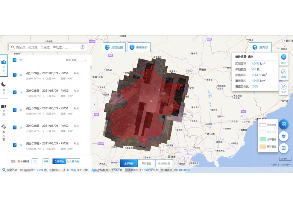
DATA MANAGEMENT SYSTEM
SATELLITE DATA MANAGEMENT FEATURES
1
The data management system is the center of the storage, management and application service of satellite data products.
2
It is mainly responsible for the storage, organization, application, management and maintenance of JL1 satellite service products.
SATELLITE DATA MANAGEMENT ADVANTAGES
1
Improved Data Accuracy: With the help of satellite data managementsystems, satellite data can be processed and analyzed in real-time. This can help improve the accuracy of data as it is less prone to errors caused by manual processing.
2
Better Decision Making: Satellite data management systems can provide near-real-time information about various aspects of the Earth's satellite environmental monitoring, such as weather patterns, vegetation, and natural disasters. This information can help decision-makers make informed decisions regarding resource management, disaster response, and environmental protection.
3
Cost-Effective: Satellite data management systems can be cost-effective compared to traditional data collection methods. For example, satellite data can cover large areas quickly and efficiently, reducing the need for ground-based data collection.
4
Timeliness: Satellite data management systems can provide data in near-real-time, allowing for faster decision-making and response to events such as natural disasters.
5
Consistency: Satellite data management systems can provide consistent data over time, allowing for better tracking of changes in the Earth's environment.
6
Accessibility: Satellite data can be accessed from anywhere in the world, making it a valuable tool for global monitoring and decision-making.
7
Satellite remote sensing technology: Satellite data management systems can be used to monitor remote or hard-to-reach areas that are difficult to access using traditional data collection methods.
Changguang Jilin 1 satelliteconstellation is the core project under construction by CGSTL. The first phase of the project consists of 138 high-performance optical remote sensing satellites covering video, high resolution, wide band, infrared, multispectral and other series.
Send product request
Other supplier products
 |
Satellites Testing Services | The satellite communication testingservices of CGSTL mainly consist of optical manufacture, small satellite testing, and customized service. SAT... |
 |
PUSH BROOM SCANNING SERVICE | The massive imagery archieved data and task programming data that cover all over the world captured by Jilin 1constellation. Great view and great d... |
 |
NIGHT SATELLITE IMAGE | Satellite View of Earth at Night The SP and GF03C satellites of JL1 constellection can conduct fast shooting with high-resolutions and multispectr... |
|
|
SATELLITE DATA MANAGEMENT | DATA MANAGEMENT SYSTEM SATELLITE DATA MANAGEMENT FEATURES 1 The data management system is the center of the storage, management and applicatio... |
 |
MULTI SPECTRAL IMAGERY | Multispectral Image Data The GP satellites of JL1 constellection have 26 spectral channels, covering optical remote sensing data from visible ligh... |
Same products
 |
PHOTOGRAMMETRY REMOTE SENSING | Seller: Chang Guang Satellite Technology Co., Ltd. | Photogrammetry remote sensingis to obtain reliable information about the earth, its environment a... |
 |
MARINE REMOTE SENSING | Seller: Chang Guang Satellite Technology Co., Ltd. | MARINE REMOTE SENSING Ocean colour remote sensingrefers to remote sensing that takes the ocean a... |
 |
NIGHT SATELLITE IMAGE | Seller: Chang Guang Satellite Technology Co., Ltd. | The SP and GF03C satellites of JL1 constellection can conduct fast shooting with high-resolutions... |
 |
MULTISPECTRAL IMAGES IN REMOTE SENSING | Seller: Chang Guang Satellite Technology Co., Ltd. | Multispectral remote sensing refers to the multispectral data remote sensingtechnology that divid... |
 |
MULTI SPECTRAL IMAGERY | Seller: Chang Guang Satellite Technology Co., Ltd. | The GP satellites of JL1 constellection have 26 spectral channels, covering optical remote sensin... |


